St. Johns River WMD Highlighted Springs Protection and Water Conservation in April
The Governing Board of the St. Johns River Water Management District proclaimed April 2026 as Springs Protection Awareness Month, highlighting the importance of protecting Florida’s springs and the groundwater systems that sustain them.
Concurrently, the District partnered with the Florida Section of the American Water Works Association and other state and local entities to recognize April as Water Conservation Month, highlighting the importance of protecting Florida’s water resources through responsible water use.
April is typically one of the driest months of the year in Florida, when landscape irrigation demands are often highest.
The designations come as dry conditions remain persistent across the state resulting in the entire state being classified at a minimum of moderate drought while portions of northern and southern counties continue to experience severe to extreme drought according to the U.S. Drought Monitor.
In response to declining groundwater levels and ongoing dry conditions, the District declared a Modified Phase II Severe Water Shortage for portions of northeast Florida.

Florida’s aquifers provide the bulk of potable supply in the state, as 90 percent of the state’s residents rely on groundwater for their drinking water. Florida is home to more than 1,000 natural springs, the highest concentration in the world. SJRWMD is home to 148 of those springs, eight of which receive additional protection under state law as designated as Outstanding Florida Springs.
Springs are a visible connection to the Floridan aquifer, the primary source of drinking water for most Floridians.
“Florida’s springs are among our state’s most valuable natural resources,” said St. Johns River Water Management District Executive Director Mike Register. “Protecting them means conserving water, improving water quality and continuing restoration work with our partners across the region.”
Residents can also help by conserving water, maintaining septic systems and limiting fertilizer use.
FDEP Reaches a Seafloor Mapping Major Milestone
The Florida Department of Environmental Protection has reached a major milestone in its Florida Seafloor Mapping Initiative (FSMI). The Department completed all airborne LiDAR data collection and has received the majority of vessel-based sonar data used to map Florida’s coastal waters.
Florida is the only state in the nation undertaking a seafloor mapping initiative at this scale. Once complete, FSMI will deliver the most comprehensive map of Florida’s seafloor ever created. The data is scheduled to become publicly available in fall 2026.
“Florida’s coastline is one of our state’s greatest natural and economic assets, supporting millions of residents, tourism, commercial fisheries and critical infrastructure,” said DEP Secretary Alexis A. Lambert. “Understanding the seafloor and the features that shape our coast helps us make smart decisions about protecting communities, strengthening resilience and investing taxpayer dollars where they will have the greatest impact.”
FSMI data is being integrated with inland elevation datasets through collaboration with the U.S. Geological Survey’s Coastal National Elevation Database Applications Project. The result will be a seamless statewide digital elevation model extending from Florida’s uplands to offshore bathymetry.
The Department’s high-resolution seafloor data will be available to support a wide range of coastal management decisions, including identifying offshore sand sources for beach nourishment, improving storm surge and flood modeling and guiding the protection and restoration of coral reefs and seagrass beds.
“Through FSMI, we have mapped more than 75,500 square kilometers using LiDAR and more than 64,000 square kilometers using sonar technologies,” said Florida Geographic Information Officer Kimberly Jackson. “Before this initiative began, only about 25,600 square kilometers of Florida’s seafloor had been mapped. Today, we have mapped more than 14 times that amount, giving Florida an unprecedented understanding of its underwater landscape.”
For more information about the Florida Seafloor Mapping Initiative, visit FloridaGIO.gov.
Suwannee River WMD Enacts Water Shortage Conservation Measures
The SRWMD has enacted enhanced water shortage conservation measures, including declaring a Modified Phase II Water Shortage, taking effect on April 22, 2026.
The District’s Hydrologic Conditions Report highlights rainfall, surface water and groundwater levels, provides a climate and drought outlook, as well as other scientific data. For the month of March, district staff measured an average rainfall of 1.37 inches, which was approximately 69 percent lower than the 1932-2025 average of 4.46 inches.
For the 12-month period ending March 31, staff calculated a Districtwide rainfall deficit of 19.98 inches. This deficit is a significant increase from the 15.37-inch deficit seen at the end of February. In addition to rainfall shortages most of the river gages in the District finished March in the extremely low (less than 10th percentile) flow range.
In a trend being observed throughout the state’s water management districts. SRWMD’s Upper Floridan Aquifer levels ranged from extremely low (less than 10th percentile) to normal (25th to 75th percentile) levels for the month and ended March with a Districtwide average around the 17th percentile.
The full report can be found on the District’s website under the Science & Data tab. It is typically updated the second week of each month. Reports from the previous five years are also available.
Massive Atlantic Sargassum Blooms Traced Back to West Africa
Contrary to current assumptions, the University of Miami’s Rosenstiel School has found the massive blooms of Sargassum seaweed that have plagued coastlines across the Atlantic for the last decade and a half likely originated off the coast of West Africa. It appears the blooms form years before they are visible.
The study, “Tracing the origin of tropical North Atlantic Sargassum blooms to West Africa,” published in the journal PNAS Nexus, shows the blooms can be tracked back to coastal waters near the Gulf of Guinea up to two years before being detected by satellites in the western Atlantic.
“Sargassum blooms have had enormous ecological and economic impacts across the Caribbean, Gulf of Mexico, South Florida and West Africa,” said lead author Francisco Beron-Vera, a research professor in the Department of Atmospheric Sciences at the Rosenstiel School.
Researchers used two independent analytical approaches: Bayesian inversion, which estimates the most likely source based on where and when the bloom was observed and transition path theory, which identifies the most efficient transport pathways feeding the bloom. Both methods pointed to the same origin region near coastal West Africa, particularly the Gulf of Guinea.
“Understanding the origin of these blooms gives us a much stronger foundation for predicting future events,” co-author María Josefina Olascoaga said.
JEA Launches Public Access Interactive Development Tracker
JEA launched an interactive map in April allowing customers to observe active Water/Wastewater development projects in JEA’s service territory. The tracker is designed to make doing business with JEA easier by providing real-time visibility into project status.
Customers can use the map to track the progress of their own projects while also viewing nearby developments. The tracker was implemented to support better coordination and collaboration across the development community. It shows projects updated status during the design and construction process, providing six status levels: Under Review, Plan Approved, Project Approved, Project Under Construction, Project Substantial Completion and Project Complete (within the last two years).
Detailed views provide descriptions of projects, their status and a link to project’s electronic plan submissions (SagesGov). The searchable map can be found on jea.com’s Water and Wastewater Development page.
Audubon Tracks Rare Banded Roseate Spoonbill
Although Audubon staff have been monitoring two Roseate Spoonbill colonies for 30 years in the Tampa Bay area and added hatchling banding in 2013, spotting a banded Spoonbill is rare.
Audubon Everglades Research Station conducts weekly surveys of Roseate Spoonbill colonies in Florida Bay during nesting season to get nesting and general population data.
In total, Audubon has banded about 3,000 Roseate Spoonbills, an indicator species for Everglades ecosystem health. Banding spoonbill chicks has led to a greater understanding of dispersal rates and behavioral structures after nesting season in the Florida Bay is over.
Wading Bird Research Specialist Shauna Sayers recently caught sight of an elusive band on the leg of a Roseate Spoonbill early this year. According to the letters on the band, the male spoonbill had been banded on Pigeon Key in 2021, so he’s at least six years old.
Anyone who submits a report in 2026 will receive a limited-edition sticker. However, Audubon cautions to give birds their space when trying to read a bird band. Use binoculars or a long zoom lens to avoid spooking or flushing the birds.
FPL Reports Lowest-ever Frequency of Outages in 2025 while Saving $1B in Fuel Costs
Florida Power & Light Company (FPL) matched its best reliability performance record in 2025, achieving the lowest outage frequency in company history according to its Annual Distribution Reliability Report filed with the Florida Public Service Commission.
Known for its sustainability posture, FPL is the largest clean energy company and the third-largest energy company in the U.S. according to their annual report. By leveraging a diverse energy mix, including nuclear, natural gas, solar and battery storage, FPL has earned the ReliabilityOne® National Reliability Award for eight of the last 11 years.
The utility announced in April that it had surpassed $1 billion in customer fuel savings in 2025, the result of systematic, smart investments in fuel-efficient technologies over the past two decades. Actions to increase efficiency include using fuel-efficient natural gas, replacement of inefficient oil burning plants, use of zero-emissions nuclear power, solar energy generation and cutting edge battery storage.
The utility credits a variety of innovations, such as Smart Grid technology, for making the difference. FPL’s investments in intelligent devices, such as automated switches, are delivering results for its customers. These devices helped avoid more than 17 million customer interruptions – including more than 1.6 million in 2025 reflecting a reliability that is 67 percent better than the national average.
Audubon Reports Extreme Conditions at Corkscrew Swamp Sanctuary
Staff at Corkscrew Swamp Sanctuary only recorded 0.7 inches of rain in March, though the average for March is 2.55 inches.
“We’ve only received about half of the rain that we’ve typically received by this time in the dry season, which runs October through March,” said Director of Conservation Shawn Clem. “That brings us to 39.81 inches of rain since June, which is 26 percent lower than average.”
According to park staff, over the past 17 months, only one month recorded average or above-average rainfall (May 2025). Swamp water levels remain higher than one would expect from the low rainfall, but that is expected to change. Recession rates are currently high due to warm daytime temperatures.
Quickly receding water levels can stress ecosystems, requiring wildlife to have to adapt quickly to the dry conditions. Impacts of repeated “unusually dry” periods may result in loss of food and foraging habitat, impact to breeding and nesting sites, increased vulnerability to predators and wildfires.
“We expect Lettuce Lakes could dry down by the end of April if we don’t get considerable rainfall,” said Clem. Historically, the Lettuce Lakes would dry down an average of once every five years, but this has happened more frequently in recent decades.
Orlando Utilities Commission Undertakes This Year’s Annual Burns for Environmental Growth and Sustainability
OUC has begun its annual controlled program of prescribed burns in the southeast at the Stanton Energy Center. Prescribed burns help reduce brush and vegetation buildup that can fuel wildfires.
In addition to promoting safety, the prescribed burn program supports habitat restoration for the listed, Red-cockaded Woodpecker, a threatened species in Central Florida.
The annual burns are required by the U.S. Fish and Wildlife Service, the Florida Division of Forestry and the Florida Fish and Wildlife Conservation Commission. They play an important role in maintaining a healthy ecosystem by recycling nutrients back into the soil, encouraging new plant growth and supporting species with declining populations.
Details of the protection of wildlife and their habitats within the Stanton Energy Center’s 3,200-acre nature preserve can be accessed by visiting OUC.com/Stanton.
IFAS Reports on Blueberry Growers Work to Bounce Back after Freezes
In the midst of the March and May harvesting season, Florida blueberry growers are working to recover from this year’s freeze that impacted both blossoms and fruit.
“Growers have already begun their recovery efforts, said Doug Phillips, statewide blueberry Extension coordinator for the UF Institute of Food and Agricultural Sciences (UF/IFAS). “These efforts are intended to promote plant health and recovery, with an eye toward having a full crop for the 2027 season.”
Over the 80-plus-year history of the UF/IFAS blueberry breeding program, researchers have developed about 70 varieties. The latest should please the palate. They include ‘Sharper,’ ‘Falcon’ and ‘Sentinel,’ which produce high yields and flavorful fruit, according to IFAS.
“There will be Florida blueberries in the market this spring, although the volume will be less than in a typical season,” Phillips said. “Harvest is starting in the south region that was less damaged by the freeze, as well as in the north in protected tunnels.”
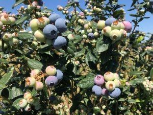
‘Falcon’ cultivar blueberries on bushes. Courtesy, UF/IFAS.